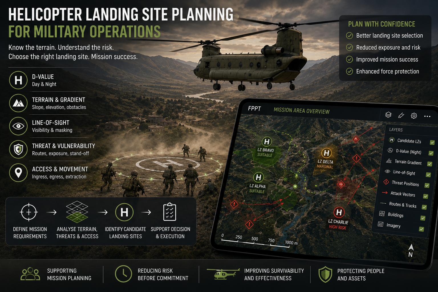
For military helicopter operations, a landing site is not just a place where the aircraft can get on the ground. It is a point in the mission where speed, exposure, terrain, aircraft performance, personnel movement and threat all meet.
A site may appear large enough. It may be close to the objective. It may look acceptable on a map. That does not mean it is the right site.
For military users, helicopter landing site planning needs to answer a more operational question: Can this location support the mission while managing the risk to the aircraft, crew and personnel?
That is where Helicopter Landing Site (HLS) capability within CRSL’s Force Protection Planning Tool (FPPT) becomes part of the wider force protection picture.
More than a flat piece of ground
A potential landing site needs to be assessed against the aircraft and the task.
For military operations, that may include troop insertion, extraction, casualty evacuation, resupply, forward support or temporary helicopter operations. Each task changes the planning requirement.
Aircraft D-value matters, including day and night D-value where relevant. Gradient matters. So do obstacles, wires, buildings, tree lines, approach and departure routes, surface conditions and surrounding terrain.
However, military planning cannot stop at physical suitability. A landing site also needs to be considered against mission timing, movement routes, proximity to the objective, exposure on the ground and the likely threat environment.
The core issue is not simply whether the aircraft can land. It is whether the aircraft can land, complete the task and depart without creating avoidable risk.
Terrain, exposure and the tactical picture
Terrain shapes the options available to the planner.
It can provide cover and concealment. It can mask movement. It can restrict observation. It can also channel aircraft and personnel into predictable routes, create dead ground, limit escape options or expose the aircraft during approach and departure.
A landing site that looks acceptable in isolation may become unsuitable once the wider tactical picture is considered.
It may sit within clear line-of-sight from elevated ground.
It may force personnel to move across open ground.
It may place the aircraft too close to likely threat positions.
It may provide poor options for departure if the situation changes.
It may be technically usable, but tactically weak.
FPPT allows landing site options to be reviewed in context, not as isolated map points.
Vulnerability before, during and after landing
Helicopters are vulnerable at different stages of an operation.
In flight, they may be exposed to observation, line-of-sight threats and attack vectors shaped by terrain, buildings or elevated ground.
During approach and departure, the aircraft may be more predictable, closer to the ground and constrained by route, speed and profile.
On the ground, the aircraft is static or slow-moving while troops deploy, casualties are loaded, equipment is moved or personnel recover into the aircraft.
That ground phase can be one of the most exposed parts of the operation.
The landing site therefore needs to be assessed not only as an aviation location, but as a vulnerability point.
A closer site may reduce movement time but increase exposure.
A more distant site may improve survivability but add pressure to the ground move.
A masked site may reduce observation but complicate approach or departure.
There is rarely a perfect answer. The value is in comparing options before commitment.
CASEVAC and personnel recovery
Casualty evacuation places immediate pressure on the planning process. The aircraft may need to get close to the casualty, but proximity alone is not enough.
A close landing site may be too constrained, too exposed, unsuitable for the aircraft, difficult to access or inside a threat envelope. A site slightly further away may provide a better balance between landing suitability, movement route, protection and speed of recovery.
The same applies to troop extraction.
The extraction point must work for the aircraft, but it must also support the movement of personnel into the site, loading under pressure and departure from the area.
FPPT supports that assessment by allowing planners to consider landing site suitability alongside line-of-sight, terrain masking, possible threat locations, movement routes and exposure during deployment or recovery.
Day and night operations
Night operations can reduce visibility to an adversary, but they also increase the importance of planning detail.
Terrain, wires, boundaries, surface conditions, gradient and access can be harder to interpret from the air. Sites that appear straightforward by day may require more cautious assessment at night.
Day D-value and night D-value may also affect whether a candidate location remains suitable.
For military users operating in unfamiliar terrain, landing site planning needs to account for both the aircraft and the conditions in which the mission will be flown.
Pre-arrival analysis does not replace aircrew judgement. It improves the quality of information available before the aircraft is committed.
Integrating HLS into FPPT
The strength of integrating HLS capability into FPPT is that the landing site can be assessed as part of the operation, rather than as a separate aviation planning task. Potential landing sites can be identified using aircraft criteria, D-value, terrain and gradient.
Those sites can then be considered against:
Line-of-sight and observation.
Threat exposure.
Approach and departure routes.
Terrain masking.
Likely attack vectors.
Troop movement routes.
CASEVAC and recovery timelines.
Exposure while the aircraft is on the ground.
This creates a more complete planning picture. It allows users to move from “where can we land?” to “which landing option best supports the mission?”
Decision support, not decision replacement
FPPT does not make the final aviation decision.
It does not approve a landing site.
It does not remove the need for aircrew assessment, command judgement or local verification.
Its role is to support planning by turning terrain, aircraft criteria and threat information into operationally useful intelligence. That allows landing site options to be identified earlier, compared more effectively and assessed against the wider risk picture before the aircraft is committed.
Better planning before commitment
For military helicopter operations, landing site selection cannot be treated as a standalone aviation task.
The site needs to work for the aircraft, but it also needs to support the mission, protect the force and reduce avoidable exposure during approach, landing, deployment, recovery and departure.
HLS capability within FPPT helps bring those factors into one planning picture.
It allows candidate landing sites to be assessed against aircraft criteria, terrain, gradient, line-of-sight, movement routes and potential threat exposure before the aircraft is committed.
The final aviation and command decisions remain with the professionals responsible for the task. The value is in giving them a clearer view of the options, the constraints and the risks before those decisions need to be made.
If you would like to explore the planning challenge further, we would be very happy to discuss the problem in more detail and, where useful, arrange a demo. Call +44 (0)1794 834750 or email enquiries@cunningrunning.co.uk. You can also follow Cunning Running Software Ltd on LinkedIn, or connect with Phil Cowell or John Overend.