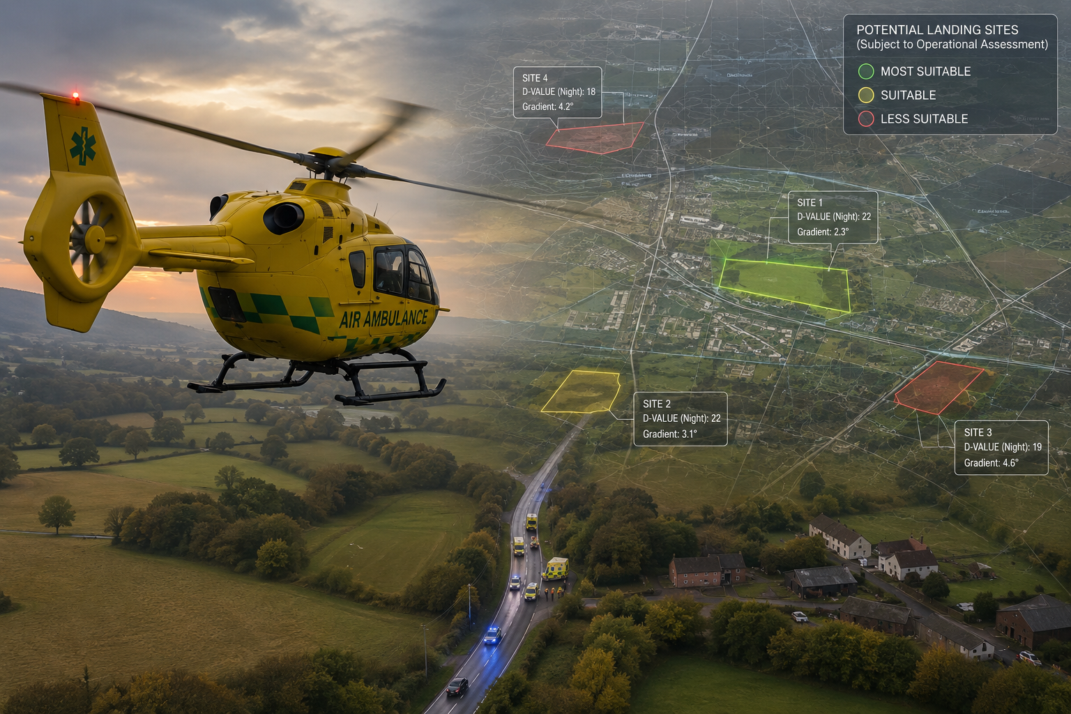
When a helicopter is operating into an unfamiliar area, the landing site decision is often made quickly, under pressure and with incomplete local knowledge.
In daylight, crews may be able to make much of that assessment visually. They can assess the ground, surrounding obstacles, approach options and local conditions from the air before committing to land. At night, that challenge becomes more demanding.
The aircraft may still be operating on an ad hoc basis, but the crew has less visual information available, less time to interpret the ground, and greater reliance on prior knowledge, procedure and airborne reconnaissance. That makes pre-arrival landing site intelligence far more valuable.
For air ambulance crews, this may mean identifying a suitable location close to a road traffic collision, rural incident, industrial site, sports ground or residential area. For military users, it may mean identifying a landing site for insertion, extraction, casualty evacuation or temporary operations in unfamiliar terrain.
The operational contexts differ, but the underlying question is the same: Where can the aircraft realistically land, and what needs to be understood before that decision is made?
A helicopter landing site is not simply open ground on a map. It needs to be considered against the aircraft, the terrain, the surrounding obstacles, the operating conditions and the purpose of the task. That is where geospatial analysis has a direct role to play.
Open ground is not the same as a suitable landing site
From a distance, many areas can appear suitable. A field may look open. A sports pitch may appear clear. A piece of land near an incident may seem like the obvious option. However, once aircraft-specific requirements are considered, the number of realistic options can reduce quickly.
For helicopter operations, aircraft size should not be treated as a generic value. Planning needs to consider the aircraft’s D-value, including day D-value and night D-value where relevant. A site that may appear suitable in daylight may not be suitable at night.
Gradient also matters. So do surrounding obstacles, available space, approach and departure considerations, surface condition, downwash risk and the wider operating environment.
The challenge is not just finding land. It is finding land that may be suitable for the aircraft, the conditions and the task.
This distinction is particularly important when crews are operating on an ad hoc basis. The site may not have been inspected in advance. Local knowledge may be limited. Time may be constrained. The aircraft may already be inbound while ground teams are still trying to identify the most practical location.
At night, those constraints become sharper. In those circumstances, better pre-incident intelligence can make a significant difference.
Turning terrain data into landing site intelligence
HLS-PRAS is designed to support helicopter landing site identification by using geospatial data to identify potentially suitable landing areas.
The software can assess terrain, gradient and available space against defined aircraft criteria. This allows users to identify candidate landing sites based on structured parameters rather than relying only on manual map checks or local assumptions.
This does not turn a piece of ground into an approved landing site. What it does provide is a stronger starting point.
It helps users narrow the search, compare options and understand the terrain before the aircraft is overhead. It can show where suitable ground may exist, where terrain may create problems, and where an apparently obvious site may be less practical than first assumed. For night operations, that pre-arrival awareness is particularly important.
Crews still need to make the final assessment, but they are not starting with a blank map.
Airborne reconnaissance still matters
When an air ambulance approaches an ad hoc landing site, the crew may still conduct one or more circuits before landing.
That is not wasted time. It is part of the final airborne assessment of the site. The pilot and crew still need to assess the landing area, obstacles, wires, surface, slope, approach and departure, downwash risks and the wider environment before committing to land.
HLS-PRAS does not remove that requirement. Its role is to improve the information available before that final assessment begins. By identifying candidate landing sites in advance, based on terrain, gradient, aircraft D-value and other agreed criteria, the software can help reduce uncertainty before the aircraft arrives overhead. The pilot still makes the operational decision.
The difference is that they are not starting from a blank map.
Why this matters for air ambulance operations
Air ambulance organisations often operate into locations that were never designed as landing sites. Roadside incidents, rural casualties, urban edge locations, public spaces and remote locations all present different challenges. Crews may know some areas well, but no service can rely entirely on memory or informal local knowledge across a full region.
That becomes more important when operating at night. A landing site that may be relatively straightforward to assess in daylight may be harder to interpret after dark, particularly where terrain, wires, boundaries, trees, slopes or nearby infrastructure are involved.
HLS-PRAS can support the identification of candidate landing sites across an operational area. This can help build a better understanding of where potential options exist before they are needed.
For control rooms and operational teams, this type of information can support faster awareness around possible landing options. For crews, it can provide useful context near an incident. For planning teams, it can support regional analysis, training and review.
The value is not in replacing operational judgement. The value is in giving teams structured, terrain-led intelligence to support it.
A service option as well as software
Not every organisation needs to operate HLS-PRAS directly. For organisations that need the output rather than the software platform, CRSL can generate regional helicopter landing site data as a service.
This can be based on agreed criteria, including aircraft D-value, day and night requirements, gradient and other operational parameters. The output can be supplied as geospatial data, including KMZ files, for use in compatible operational systems such as Airbox ACANS.
This provides a practical route for organisations that want helicopter landing site intelligence available within existing workflows. Instead of starting from a blank map during an incident, users can have a prepared layer of candidate landing site information available when required.
Wider use beyond air ambulance
Although HLS-PRAS has clear relevance to air ambulance operations, the capability is not limited to that environment. Helicopter landing site analysis also has value for military, police, resilience and emergency planning users.
Within CRSL’s wider software capability, helicopter landing site analysis can support military force protection planning through FPPT and wider operational planning through CTS-PRAS where appropriate.
For military users, the question is not only whether a helicopter can land. It is whether the landing site supports the mission. That may involve identifying landing options for troop insertion, extraction, casualty evacuation or temporary helicopter operations. It may also involve considering approach and departure, exposure on the ground, proximity to the objective, and the wider risk environment.
Within FPPT, helicopter landing site planning can also sit alongside other forms of analysis, including line-of-sight, threat assessment and aircraft vulnerability. That includes assessing aircraft in flight, on the ground, and during the deployment or recovery of personnel.
That wider military use case will be covered later in this series.
Planning should not start when the aircraft arrives
The common thread across helicopter landing site operations is the need to reduce uncertainty. A map can show open ground. A photograph can show what an area looks like. Local knowledge can provide useful context.
However, none of those on their own provides a consistent way to assess terrain, gradient, aircraft D-value, day and night requirements, and landing area suitability across a whole region. HLS-PRAS helps turn that data into operationally useful intelligence.
For air ambulance crews, that can support faster awareness around ad hoc landing sites, particularly during night operations.
For organisations that need prepared data, regional landing site outputs can be provided as a service.
For military and security users, the same capability can support wider planning around aircraft operations, force protection and vulnerability assessment.
The aircraft may still be the first asset to arrive overhead. The planning does not need to start there.
If you would like to explore the planning challenge further, we would be very happy to discuss the problem in more detail and, where useful, arrange a demo. Call +44 (0)1794 834750 or email enquiries@cunningrunning.co.uk. You can also follow Cunning Running Software Ltd on LinkedIn, or connect with Phil Cowell or John Overend.